
How Much Does A Drone Lidar Survey Cost? UK Guide 2026
If you’re involved in rural planning, land design, or need topographic data for a project, you’ve likely wondered: “What’s the real cost of a drone LiDAR survey?”
It’s one of the most common questions we get at DroneWorks. Here’s a clear, no-nonsense breakdown of what influences pricing, why it varies, and how to get the best value for your project..
How Much Does A Drone Lidar Survey Cost? UK Guide 2025
How Much Does A Drone LiDAR Survey REALLY Cost?
What Factors Influence the Cost?
How to Get the Most Value for Your Budget
So, How Much Will YOUR LiDAR Survey Cost?
Typical Price Ranges for Rural LiDAR & Topographic Surveys
Credentials - Always Use A Qualified, Insured Drone Operator
How Much Does A Drone LiDAR Survey REALLY Cost?
When it comes to drone surveys, every job is different and costs will vary. Like many professional services … it depends. 😬 Not very helpful I know!
There is much more to a drone lidar survey than simply flying the drone. The drone is a tool. The magic is in the deliverables and outputs created from the drone data and of course the data needs to be collected in the correct, systematic way.
What even is a drone survey? Read more about that here.
Let’s break it down so you can better understand what goes into pricing a drone survey.
Why Drone Survey Costs Vary
Every drone survey is tailored to meet the unique needs of a client’s project. Factors like the type of data required, the size and complexity of the site and the level of detail needed, all affect the final price.
Here’s a closer look at the key elements that influence costs:
Project Size & Complexity
Deliverables
Technology & Methods
Lets look into those elements in a bit more detail....
Spoiler: LiDAR surveys cost more than a standard photogrammetry survey!

Do You EVEN Need LiDAR? Or A drone for that matter?
Lidar has become a bit of buzz word over the past year as awareness has increased, the cost of equipment has come down.
However, if your site is smaller than 10ha, you might not even need a drone survey. A traditional survey may yeild the results you need at a comparible cost and time.
However, if you have a large rural area to cover in the region of 20ha - 100ha, this could take a traditional survey team a long time and dependong on the terrain, may not even be feasible.
As for the LiDAR, it is best used when you need accurate levels in vegetated areas such as woddland and forests. Otherwise, a standard photogrammettry survey could be better (and cheaper) for your situation.
What even is a drone survey? Read more about that here.
What Factors Influence the Cost?
No two rural sites are the same, so pricing is shaped by several key factors:
1. Size of the Survey Area
A 2-acre paddock is a different job to a 120-acre estate. Larger sites need more flight time, more data collection, and more processing.
2. Site Complexity & Accessibility
Open fields are straightforward, but sites with woodland, water features, steep slopes, or livestock require extra planning and sometimes specialist equipment.
3. Level of Detail & Deliverables
Are you looking for a basic contour map, or do you need a classified, colourised point cloud or detailed CAD-ready outputs? What level of detail do you need in the CAD drawings? The more detail, the more work involved in data processing and quality checks.
4. Equipment & Technology
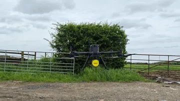
We use advanced kit (DJI M350 RTK drone and Rock Robotic R3 Pro LiDAR) for high-accuracy, high-density data - even through dense vegetation. This ensures reliable results for planning applications, drainage design, and much better data than from the DJI L2 which most of our competitors are using.
5. Travel & Mobilisation
Sites further afield, or those requiring extra access arrangements, can add to the overall cost.
6. Turnaround Time
If you need results urgently, we can often accommodate - but a fast turnaround may carry a premium.

Why Does Pricing Vary?
Every site is different: A simple, open field is quicker to survey than a site with woodland, watercourses, or multiple boundaries.
Different deliverables: Some clients need basic topographic data, others require detailed CAD files for design and planning.
Access & permissions: Sites with restricted access, livestock, or public rights of way may need extra planning or safety measures.
Regulatory requirements: Planning applications or projects near protected areas might need additional risk assessments or permissions.
How to Get the Most Value for Your Budget
1. Define Your Needs Early
Be clear about what you need: contour intervals, output formats (e.g., CAD, PDF, 3D models), and any site-specific challenges.
2. Prioritise Deliverables
Not every project needs every output. If you only need a DTM or a specific area mapped, let us know—you won’t pay for unnecessary extras.
3. Bundle Surveys
If you have multiple sites or need regular monitoring (e.g., for phased developments), combining surveys can reduce the per-site cost.
4. Choose Qualified, Insured Operators
Professional, CAA-approved teams (like ours) minimise risk, ensure data accuracy, and help avoid costly mistakes or reshoots.
5. Ask About Turnaround
Standard delivery is 7 days, but if you need results faster, let us know. We’ll always be upfront about what’s possible.
CAD Deliverables
A topographical survey (aka topo survey) is an accurate depiction of a site (property, area of land, defined boundary) which is scaled and detailed to show all the natural and manmade features and their levels.

A topo survey gathers spatial information relating to the site and is usually to the national Ordnance Survey grid (osgb36) and datum information (often using GPS) and is surveyed by point.
When commissioning a topo survey you will need to specify the level of detail you require to be extracted to the CAD deliverable.
As standard, the CAD topo will include a grid spot heights at a pre defined spacing, e.g. 10m. We can extract this grid at your required interval. 10m is usually standard.
LiDAR Data is usually accurate to 3cm to 5cm absolute accuracy. We perform QA / QC process to confirm this to ensure you always get accurate data.
The different elements included in a survey will depend on the requirements of the client. Typical elements that may be part of a topographic survey include the following:
Area boundary lines
Roads
Buildings and structures
Street furniture street lamps, traffic lights and signs, man hole covers)
Trees, bushes and vegetation positions
Water channels (such as brooks, streams, ponds and lakes)
Ground heights, contours and surfaces
Drainage features
Water levels
By giving clear requirements, you will only pay for the information that you need. The more detail required, the more time it will take.

So, How Much Will YOUR LiDAR Survey Cost?
The honest answer is that it depends. A small project might start at £1200 + VAT, while a comprehensive LiDAR survey with CAD deliverables for a large area can exceed £3,000 - £5,000.
On average, most drone LiDAR surveys fall around £2500 - £3000 but every project is unique.
At DroneWorks, we are not necessarily the cheapest, or the most expensive but we have a high level commercial equipment including the DJI M350 RTK, Rock Robotic R3 Pro Lidar AND the experience to apply the correct equipment and software to get you the right deliverables.
We work closely with our clients to understand their specific needs and provide a clear, detailed quote upfront. Whether you’re looking for raw data or a full-service solution, we’ve got you covered.
Cheapest is not always best, but you should ensure your requirements are understood and check that the chosen operator has the correct credentials and experience to deliver what you need.
Typical Price Ranges for Rural LiDAR & Topographic Surveys
Here’s what you can expect from DroneWorks:
Note that doubling the survey area does not necessarily double the cost.
Small rural sites (up to 10ha / 25 acre):
£1,200 – £2,000
Medium sites (up to 50ha / 125 acre):
£1,800 to £2,700
Large/complex sites (100ha+ / 250 acre+):
£3,000 – £5,000+
All prices are guidelines; your actual quote will depend on the specifics of your site and requirements.
BONUS: The Problems (and solutions) with LiDAR Survey?
See our blog for a no-nonsense breakdown of what influences pricing, why it varies, and how to get the best value for your project..
https://blog.drone-works.uk/post/top6-lidar-drone-survey-problems-and-solutions
How Can DroneWorks Help you?
When you enquire about a lidar survey, we will guide you through the process and advise on the best course of action to meet your requirements.
As standard we will provide:
Pre-site planning, risk assessments, and permissions
On-site data capture by licensed, insured pilots
High-spec LiDAR equipment (DJI M350 RTK & Rock Robotic R3 Pro)
Data processing, QA/QC, and deliverables tailored to your needs (contours, 3D models, CAD files, etc.)
£5m public liability and £2m professional indemnity insurance
Clear communication and post-project support
Flexibility - every client and survey is different
Credentials - Always Use A Qualified, Insured Drone Operator
We are a bona-fide ltd company, with the relevant experience and credentials for this type of work.
All surveys are planned, risk assessed and conducted safely, with RAMS (Risk Assessment Method Statement) created for every job.
We operate in the specific category under PDRA01
• CAA Approved / Licenced Drone Operator
• £5m Public Liability
• £2m Professional Indemnity
• ConstructionLine Gold Accredited Contractor
• CSCS Card Holders
Ready to Get Started?
If you’re planning a rural development, need accurate topographic data, or want to streamline your site design process, get in touch.
We’ll help you understand your options and make sure you get the best value for your budget.
Have questions about rural LiDAR surveys or topographic mapping? Let us know what you need - we’re always happy to help.
Remember: A drone survey is an investment in accurate, actionable data that can save you time, money, and headaches down the line. Let’s make your project a success!
If you’re ready to experience the benefits of a drone survey, we’d love to help. Contact us by phone 01772 846229 or post your enquiry via our website.
Let’s discuss how we help you leverage drone technology in your next project.