
Top 6 Drone LiDAR Survey Problems and Solutions
If you’re involved in rural planning, land design, or need topographic data for a project, you’ve heard about LiDAR, it has become a buzz word in surveying recently.
In this blog post, we discuss where things can go wrong and how to avoid headaches.
Top 6 Drone LiDAR Survey Problems and Solutions
The Problems with LiDAR Surveys (and solutions!)
1. Vegetation and Ground Visibility Issues
3. Flight Planning and Data Capture
4. Data Processing and Interpretation Errors
5. Limitations in Deliverables and Compatibility
Final Thoughts: Is a Drone LiDAR Survey Right for You?
The Problems with LiDAR Surveys (and solutions!)
Drone LiDAR surveys have transformed rural planning and land design - delivering fast, accurate data for everything from site layouts to flood risk assessments. But, like any technology, they aren’t perfect. If you’re considering a drone LiDAR survey for your rural or topographic project, it’s worth knowing where things can go wrong (and how to avoid headaches).
Here are the top six challenges you might face - and what they look like in the real world.

1. Vegetation and Ground Visibility Issues
The Problem:
LiDAR is known for its ability to “see through” vegetation and generate ground models - but it’s not magic. Dense woodland, thick hedges, or long grass can still obscure the ground, leading to patchy or incomplete data.
LiDAR does not actually see through vegetation. LiDAR works by emitting laser pulses and measuring the time it takes for the light to reflect back to the sensor, allowing for precise distance calculations. These lasers can find their way through gaps in the vegetation, to ground.
A good rule of thumb: if sunlight can make its way through a tree canopy, LiDAR probably can too. However, this does depend on the equipment... see problem #2!

Symptoms You Might Notice:
Survey results show “holes” or missing patches in woodland or dense scrub.
Ground levels in heavily vegetated areas seem less accurate than in open fields.
What to Know:
Even with high-density LiDAR, some ground points get blocked leaving gaps in the point cloud. If the gaps are too large, this can affect contour accuracy, especially in areas where precise elevation matters for planning or drainage.
How We Tackle It:
We recommend scheduling surveys outside peak growth seasons (if possible), and always flag areas where supplementary ground checks may be needed.
If you need to capture data in growth season, slow the flight speed to increase chance of lasers finding gaps.
2. LiDAR Specification
The Problem:

Not all drone LiDAR is equal. There many parameters that make up the specification of a LiDAR unit.
The ultimate value of a LiDAR scanner lies in its ability to deliver data at the quality, accuracy, and efficiency levels you need.
Read this article for a basic understanding of LiDAR technology.
Here are some factors to consider:
Point Cloud Density: The number of data points captured by a LiDAR scanner within a specific area or volume. A denser point cloud usually means more data points are collected, resulting in a more detailed and accurate representation of the scanned environment.
Accuracy and Precision: Consider the accuracy and precision of the LiDAR scanner. These factors determine how closely the scanner's measurements match the actual dimensions of objects.
Field of View (FOV): Field of View (FoV) is the portion of the scene illuminated by the lasers.Llaser pulses are fired at specific angles, creating blind zones that can be large enough to cause missed detections.
Range: the distance a LiDAR sensor can effectively detect objects, varies significantly depending on the sensor type and application. Advertised specs are usually optimistic, especially if cm accuracy is required.
Upfront Cost: Finding the sweet spot of price for performance will help you make the case. Cheaper hardware such as the DJI L2 is gaining popularity but is generally entry level capability.
Total Cost of Ownership: Every LiDAR scanner will require specific software licenses to create and quality check the resulting point cloud. Third party softwares give greater ability to refine the data and check for quality.
Symptoms You Might Notice:
Noisy data
Inconsistent data & gaps in undulating terrain
Delays in project timelines.
What to Know:
Noise is present in all LiDAR collections, but is usually minimised with higher end LiDAR units. Noise relates to erroneous points in the point cloud which interfere with the display, processing and accuracy of the data.
How We Tackle It:
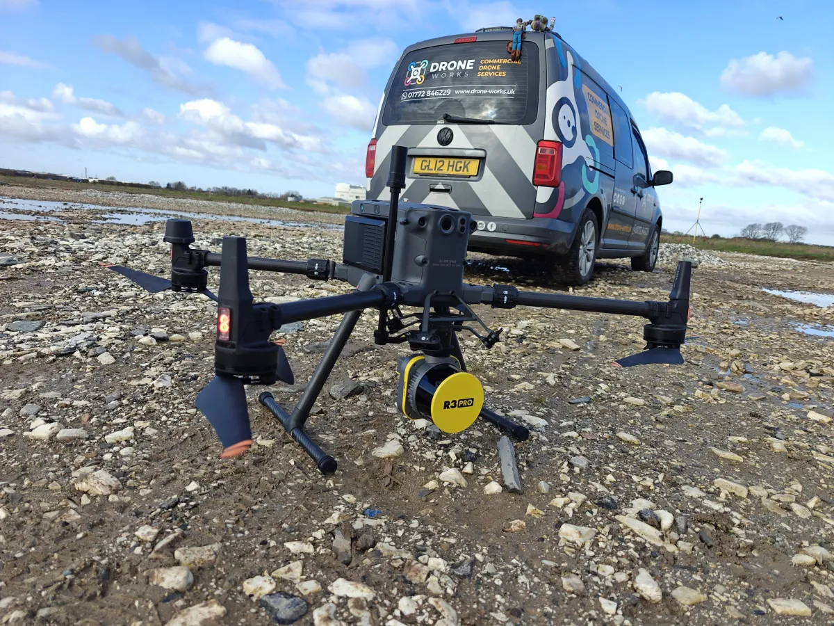
DroneWorks use higher quality lidar sensors such as the Rock Robotic R3 Pro. This is based one the Hesai XT32 laser module and produces little noise compared to the popular DJI L2 lidar unit, ensuring we're collecting accurate, noise free data from which to give you the deliverables you need to base project decisions on.
3. Flight Planning and Data Capture
The Problem:
LiDAR and drones are not a silver bullet. Like any survey, it needs to be approached methodically and systematically to ensure the data is accurate.
Symptoms You Might Notice:
low density point cloud (flying too high to too fast)
missing data in varying terrain (flight path following constant height rather than following terrain)
inaccurate data (poor planning and lack of or poor ground control)
What to Know:
LiDAR surveys are much more involved than a standard drone survey. Multiple technologies are used and must be understood to ensure success.
Effective LiDAR flight planning involves carefully considering various parameters like altitude, speed, overlap, and terrain to ensure high-quality data collection and efficient mission execution.
How We Tackle It:
All DroneWorks operators are experienced in LiDAR survey data collection and processing.
Once the survey extent is understood, we will plan ground control, base station and data capture to ensure accurate data from which deliverables will be created.
Using the Rock R3 Pro lidar on the DJI M350 RTK drone, we can cover up to 100ha (250 acre) in a single day.
4. Data Processing and Interpretation Errors
The Problem:
LiDAR surveys produce huge amounts of data. If the wrong settings are used, or if quality checks are skipped, the results can be inaccurate - or even unusable.
Symptoms You Might Notice:
Survey outputs don’t match ground truth (e.g., levels are “off” vs. known benchmarks).
Gaps, distortions, or artefacts in the final model.
Unexpected delays while errors are fixed or data is recollected.
What to Know:
A single missed setting or poor ground control can waste an entire day - leading to extra costs and lost time and poor data.
How We Tackle It:
DroneWorks use rigorous pre-flight and planning checklists, ground control points, and independent QA/QC checks built into our workflow. On site base stations are used to reduce survey base lines for high accuracy. RTK corrections via NTRIP to ensure accurate terrain following.
If something isn’t right, it will be picked up during QC checks and action can be taken.
5. Limitations in Deliverables and Compatibility
The Problem:
Not every client uses the same software or needs the same outputs. Sometimes, what’s delivered (point clouds, contours, CAD files) isn’t compatible with your systems or isn’t as “plug and play” as expected.
Symptoms You Might Notice:
Trouble opening or using LiDAR files in your design or planning software.
Needing extra time or support to convert or interpret data.
Feeling overwhelmed by the volume or complexity of the deliverables.
What to Know:
LiDAR data is powerful, but it’s also technical. If you’re not familiar with point clouds or 3D models, there can be a learning curve.
How We Tackle It:
We will discuss your requirements up front - making sure you get the right formats and deliverables for your project. We also provide support and guidance on using the outputs effectively.
6. Lidar or Photogrammetry?
The Problem:
LiDAR has become a buzz word. Many believe it is more accurate than photogrammetry, this is not the case, but both techniques have their strengths and weaknesses. Understanding them is crucial. Your surveyor should be able to help you apply the right technology to meet your requirements.
Symptoms You Might Notice:
Photogrammetry will not give levels beneath vegetation, leading to inaccurate terrain model.
LiDAR used on a site with mainly hard surfaces
Using the wrong tool for the job at hand
What to Know:
The choice between LiDAR and photogrammetry depends on the specific requirements of the project. If vegetation penetration is critical, LiDAR is the preferred choice, while photogrammetry is a more cost-effective option but also delivers higher accuracy, especially on hard surfaces.
How We Tackle It:
After understanding your requirements, we will guide you on the best course of action.
Why not have both? 😃 we always capture photogrammetry at the same time, so you get the best of both works!

Final Thoughts: Is a Drone LiDAR Survey Right for You?
LiDAR surveys are a game-changer for rural planning and topographic work but not without pitfalls. The key is working with a team that’s transparent about the challenges, proactive in problem-solving, and focused on delivering data you can actually use.
If you’re experiencing any of the issues above - or just want to know what’s possible for your site - give us a call, we’ll help you weigh the pros and cons, and make sure you get the right survey for your needs.
Alternatively Photogrammetry may be a better option, but this depends on the area to be surveyed and the deliverables you require.
BONUS: How Much Does A Lidar Survey Cost?
See our blog for a no-nonsense breakdown of what influences pricing, why it varies, and how to get the best value for your project..
https://blog.drone-works.uk/post/how-much-does-a-drone-lidar-survey-cost
Ready to Get Started?
If you’re planning a rural development, need accurate topographic data, or want to streamline your site design process, get in touch.
We’ll help you understand your options and make sure you get the best value for your budget.
Still have questions about drone LiDAR surveys? Let us know - we’re happy to talk through your project, openly and honestly.
Remember: A drone survey is an investment in accurate, actionable data that can save you time, money, and headaches down the line. Let’s make your project a success!
If you’re ready to experience the benefits of a lidar drone survey, we’d love to help. Contact us by phone 01772 846229 or post your enquiry via our website.
Let’s discuss how we help you leverage drone technology in your next project.