
🚔 When the Police Show Up: A Day in the Life of a Professional UAS Operator
Ever had your drone operation interrupted by a police visit?
We carried out a high-security, photogrammetry mission with all the correct authorisations in place; FRZ clearance, multiple levels of site access, strict compliance protocols…
And yet, mid-flight, I was told:
“The police are at the gate. They want the drone brought down immediately.”
🗺️ Mission Overview: High-Resolution Photogrammetry in a Sensitive Area
During a detailed Inspection & Photogrammetry mission at a site requiring a high level of security clearance, I encountered an unexpected interruption.
We were capturing ultra-detailed imagery - <1cm GSD - for a 3D model to support asset management and solar planning.
In turn, this would support; Asset Management, Condition Assessment, and Spatial Planning through modern visualisation.
Missions like this are ideal for generating Condition Reports and Roof Plans, another use case of which this can assist in, is the precise planning and installation of solar panels.
You can view an example of a similar output here:
https://link.drone-works.uk/chester-castle-2025
The location presented several operational challenges:
Situated adjacent to a Flight Restriction Zone (FRZ)

Bordering a Site of Special Scientific Interest (SSSI)
Accessible only via multiple layers of internal security clearance
There were many Ground Hazards in close proximity to the key focused areas
Prior to the operation, we secured the necessary:
FRZ permissions from the relevant authority
Site access approvals, including formal personal clearance from on-site security
Agreed pre & post-flight notifications issued to the appropriate security teams
Our Take-Off and Landing (TOL) zone was established beyond the second level of security in a restricted car park area, cordoned off with cones and signage.
This ensured compliance with Visual Line of Sight (VLOS) requirements and preserved consistent signal strength for the DJI Matrice 350 RTK throughout the flight.
This also ensured that any on-site personnel, even those not previously briefed, could clearly identify the operation and maintain a safe distance.
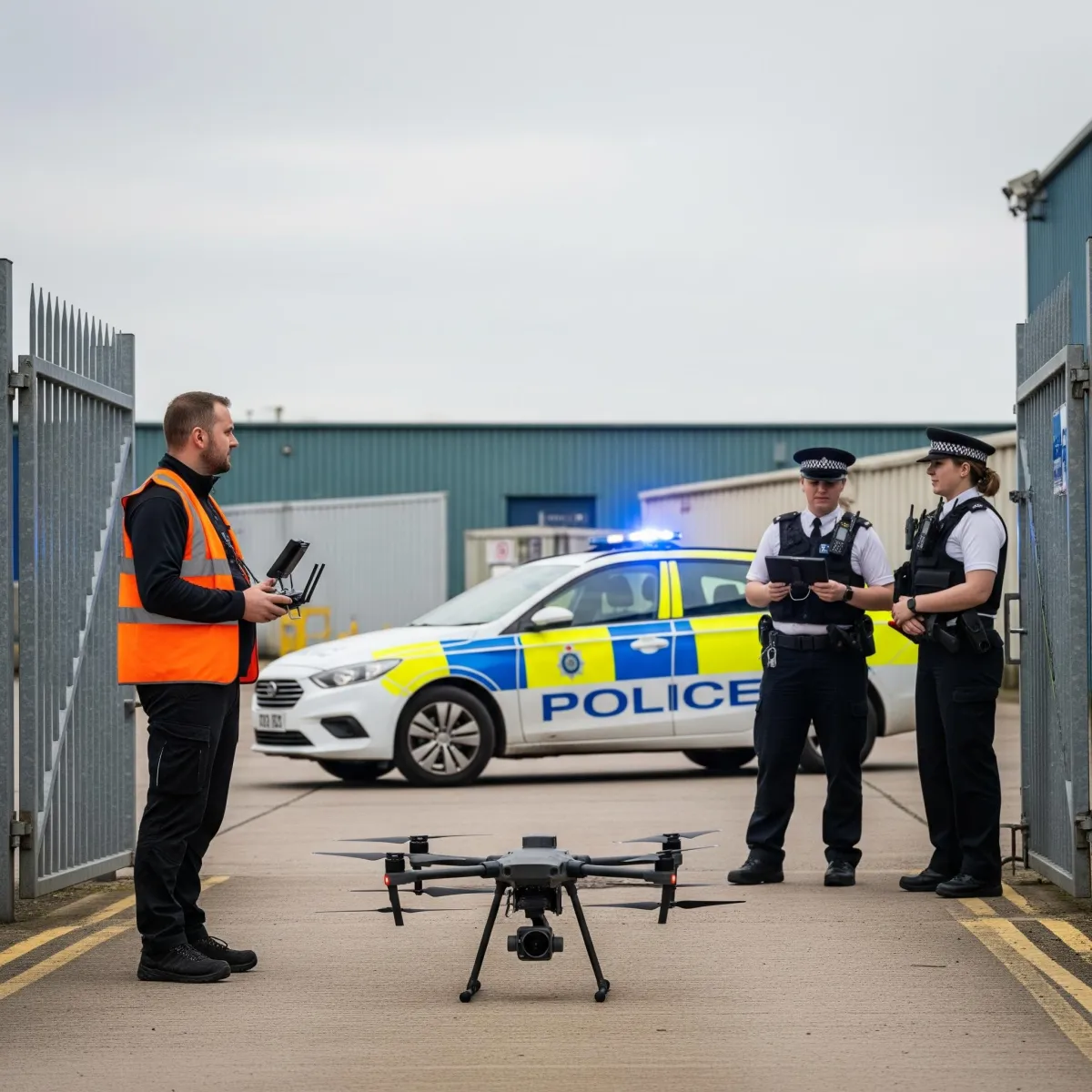
📞 Unexpected Visitors: Police Attendance on Site
Midway through the mission, on-site security notified me that police officers had arrived at the facility’s level 2 gate, and requested that the pilot bring the aircraft down immediately.
A neighbouring secure site, also heavily restricted, had reported a drone flying above its premises and had raised concerns about possible unauthorised surveillance.
Upon arrival, the police saw our beaconed DJI M350 RTK in operation, and understandably assumed it was the same drone that had triggered the complaint.
👷 Direct Engagement: Clarifying the Operation
Although security had already explained that our activity was fully sanctioned, the officers requested to speak with me directly.
After bringing the aircraft into land, I approached them, clearly identifiable in PPE and branded uniform, operating from a visibly designated launch zone with signage.
It quickly became evident that this was a regulated and authorised commercial mission.
🧠 Turning an Interruption into a Positive Interaction
Initially, the officers were firm, but courteous; wanting to know who I was and why I'm here, asking why I was flying over a restricted area.
As the conversation unfolded, it was apparent that their knowledge of UK drone regulations was limited to more recreational aspects; particularly the Flyer ID and Operator ID, one officer having experienced flying a DJI Mini.
After voluntarily providing my Flyer ID, Operator ID, UAS serial number, and Insurance Documentation, I also explained our various approvals & the Operational Authorisation(OA) we were flying under:
Our operation was conducted under the PDRA-01 OA framework
We had obtained site-specific authorisations, including FRZ clearance
All standard protocols for commercial UAS operations were being followed

Although I wasn’t obliged to provide all the details I shared, I chose to do so for the sake of transparency and to demonstrate the legitimacy of our operations.
The officers called in another unit to the neighbouring site's security, so our interaction could be thoroughly examined.
They responded positively, and our exchange ended on a helpful and respectful note.
🎯 The Real Cause for Concern

Following the interaction, as I was leaving site, I was informed by the security team that the drone in question was, in fact, a sub-250g aircraft.
The pilot was operating unlawfully within the FRZ, without any authorisation, or prior arrival notice.
Our proactive engagement and compliance with regulations had clearly set our operation apart from the unauthorised activity.
🎓 Advice for UAS Professionals
This incident highlights a few key considerations for those operating in sensitive or regulated environments:
Always be prepared for unscheduled enquiries, particularly in or near protected areas.
Maintain thorough documentation and be ready to clearly articulate your permissions and operating framework.
Use interactions with authorities as an opportunity to positively represent the drone industry, share knowledge, and help build mutual understanding.
Voluntarily sharing information proves we have nothing to hide, and are happy to cooperate.
🤝 Representing the UAS Industry Responsibly

Every interaction, whether with clients, security teams, or law enforcement, has an impact on how the public and authorities perceive the drone industry.
By operating transparently, professionally, and within the regulatory framework, we aim to elevate industry standards.
In doing so, we reinforce the image of Drones as a valuable, legitimate, and safely operated tool, not a nuisance or a threat.
👮Have you ever had blue lights unexpectedly turn up whilst on site? How did it go?
Useful Info:
PDRA:
- Pre Defined Risk Assessment
https://www.caa.co.uk/drones/specific-category/pdra01-operational-authorisation/pdra01-overview/
VLOS:
- Visual Line Of Sight
OA:
- Operational Authorisation
https://www.caa.co.uk/drones/specific-category/pdra01-operational-authorisation/
GSD:
- Ground Sampling Distance is the distance between two consecutive pixel centres measured on the ground.
- The larger the value of the image GSD, the lower the spatial resolution of the image and the less visible details.
https://www.propelleraero.com/blog/ground-sample-distance-gsd-calculate-drone-data/
Have a complex project or security sensitive job?
If you’re considering a drone survey, we’ll guide you through the options, explain what’s included, and help you choose the right solution for your needs.
Remember: A drone survey is an investment in accurate, actionable data that can save you time, money, and headaches down the line. Let’s make your project a success!
If you’re ready to experience the benefits of a drone survey, we’d love to help. Contact us by phone 01772 846229 or post your enquiry via our website.
Let’s discuss how we help you leverage drone technology in your next project.