
Case Study: Warehouse Roof Survey for PV Design - Liverpool Docks
Client: EON / Peel Ports
Project: 3D CAD & roof condition survey for PV Design
The Challenge
A large warehouse at Liverpool Docks needed a roof survey before installing solar panels. The objective was to understand the condition of the roof and to obtain accurate measuresments to assist with design plans.
Traditional surveys would have meant scaffolding, working at height, and a long wait for results.
This building is approximately 26,000 square meters of roof space.380m in lenght and 80m wide.
It is a large area to cover in detail.
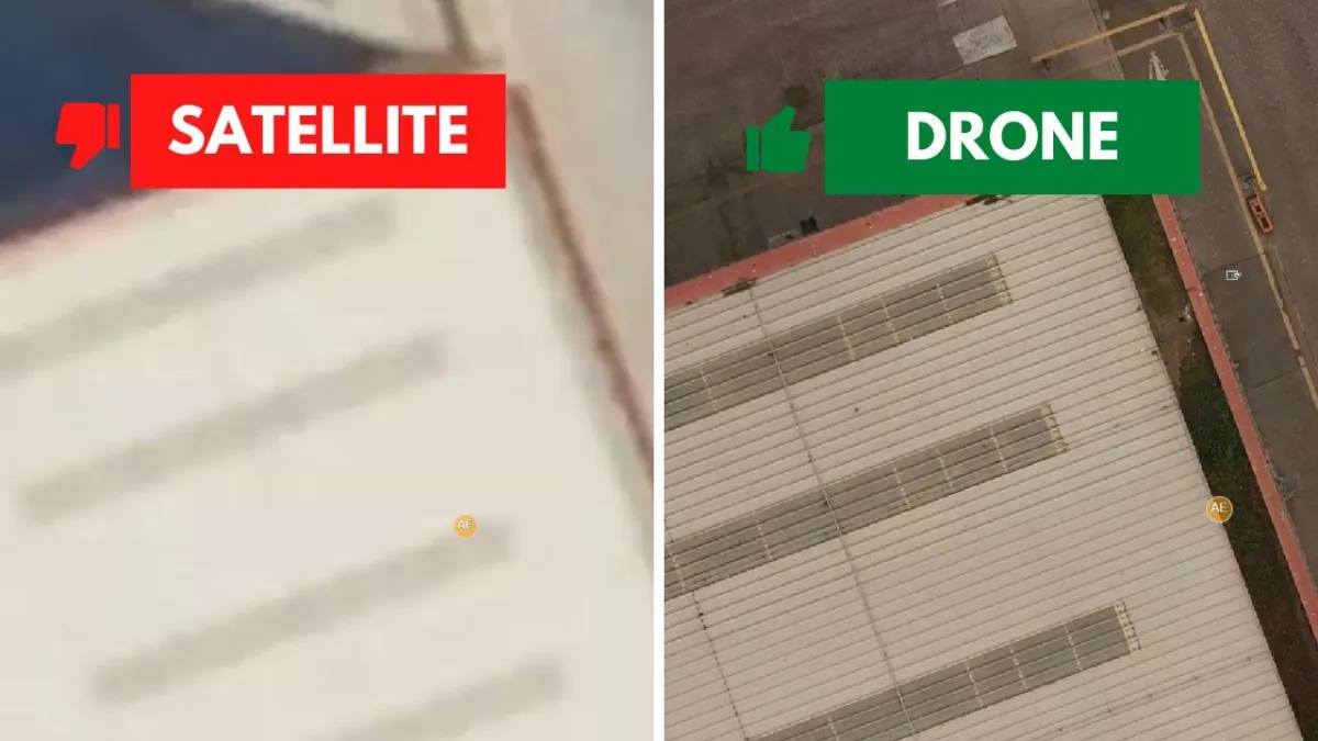
Google Maps couldn’t provide the detail or accuracy required. Due to the size of the building, there are a lot of unknowns to be determined in order to finalise the design and feasibility for the PV design.
Time
Cost
Roof sheet profile
Locating obstructions - vents, sky lights, man safe, lighting protection
Obtainin accurate dimensions and pitch of roof
Health & Safety

The Solution
DroneWorks completed a full roof inspection in a single site visit using drone technology.
High-resolution images and 3D data were captured to:
Assess the roof’s condition for PV panel installation
Identify accurate roof dimensions, skylights, vents, and man-safe equipment and any other visible obstructions
Produce CAD roof and elevation plans for the design team
All data was delivered through an interactive inspection platform, including a 3D model and a detailed surveyor’s report.
This allowed the project team and contractors to review, collaborate, and make informed decisions quickly to enable to the project to progress.

The Results
Speed: Survey and data collection completed in hours
Accuracy: Detailed, up-to-date roof and elevation plans
Clarity: 3D model and inspection report made issues easy to locate and prioritise
Collaboration: All stakeholders worked from the same data set
With the full picture and unknowns removed, the project team can now determine if any issues need to be recitifed before PV panels are installed.
The array can be designed to make best use of space, whislt working around any obstructions that would impact the installation.
On site teams can plan ahead without multiple visits to site.

Deliverables
From one site visit, DroneWorks provided multiple deliverables both online and offline.
Surveyor schedule of condition report
highlight issues to be rectified before PV panels are installed
high resolution images for inspection and audit
Accurate CAD plans - Roof plan and elevations
accurate location of skylights, lightning protection, vents and obstruction
High resolution orthophoto
This is like a very detailed google map, enabling the whole roof to be viewed in detail in a single image
Acts as a snaphot of the roof before works have started
3D Model
Context for design, planning and collaboration
Take measurements on demand

Why It Matters
For PV design projects, removing unknowns early saves time and prevents costly surprises. DroneWorks’ approach gave the team confidence in the roof’s suitability and helped streamline the design process.
One site visit - multiple outcomes
The project team and contractors accessed the 3D model online, improving context and awareness.
Collaboration was easier - everyone worked from the same up-to-date data.
CAD plans of the roof and elevations were produced for accurate reference.
All deliverables viewable in 3D, in high detail from any device with an internet connection.
How Can DroneWorks Help You?
When you enquire about a drone survey, we will guide you through the process and advise on the best course of action to meet your requirements.
As standard we will provide:
Pre-site planning, risk assessments, and permissions
On-site data capture by licensed, insured pilots
High-spec LiDAR equipment (DJI M350 RTK & Rock Robotic R3 Pro)
Data processing, QA/QC, and deliverables tailored to your needs (contours, 3D models, CAD files, etc.)
£5m public liability and £2m professional indemnity insurance
Clear communication and post-project support
Flexibility - every client and survey is different
Credentials - Always Use A Qualified, Insured Drone Operator
We are a bona-fide ltd company, with the relevant experience and credentials for this type of work.
All surveys are planned, risk assessed and conducted safely, with RAMS (Risk Assessment Method Statement) created for every job.
We operate in the specific category under PDRA01
• CAA Approved / Licenced Drone Operator
• £5m Public Liability
• £2m Professional Indemnity
• ConstructionLine Gold Accredited Contractor
• CSCS Card Holders
Ready to Get Started?
If you’re planning a PV installation, building survey, rural development, need accurate topographic data, or want to streamline your site design process, get in touch.
We’ll help you understand your options and make sure you get the best value for your budget.
Have questions about drone surveys? Let us know what you need - we’re always happy to help.
Remember: A drone survey is an investment in accurate, actionable data that can save you time, money, and headaches down the line. Let’s make your project a success!
If you’re ready to experience the benefits of a drone survey, we’d love to help. Contact us by phone 01772 846229 or post your enquiry via our website.
Let’s discuss how we help you leverage drone technology in your next project.