
Case Study: Fast, Safe Condition Survey of a 10-Storey Block
Client: Housing 21
Project: External Condition Survey - 10 Storey Block
The Challenge
The client needed a full external condition survey of a 10-storey residential block in order to determine issues in the cladding and enable the planing of any remediation works.
Traditional inspection methods would have required scaffolding, specialist access teams, and weeks of disruption. The costs and risks associated with working at height were high, and results would take weeks to arrive.
Time
Cost
Complexity
Health & Safety
The Solution
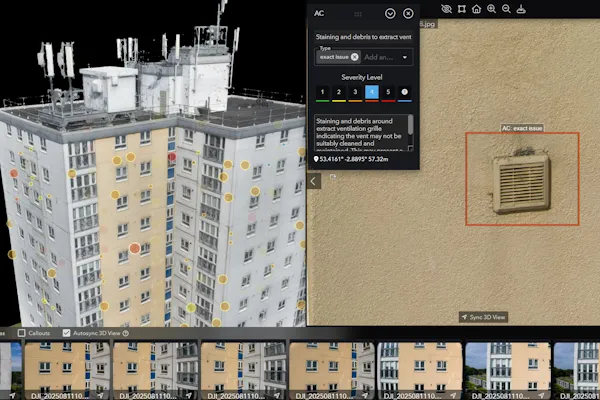
DroneWorks used drone technology to capture high-resolution inspection data in just a few hours. The team collected 500 detailed images, covering all elevations and the roof. This data was processed into an interactive 3D model, hosted on a secure inspection platform.
The project team and contractors accessed the 3D model online, improving context and awareness.
Collaboration was easier - everyone worked from the same up-to-date data.
CAD plans of the roof and elevations were produced for accurate reference.
The Results
Speed: Survey completed in hours, not weeks.
Safety: No scaffolding, no working at height.
Clarity: Full scehdule of condition report hosted in an interactive 3D model, CAD Plans and images giving a full visual record - easy to review, share, and discuss.
Efficiency:Detailed surveyor’s condition report prepared inside the platform. Issues were located, categorised, and reviewed quickly.
Decision-Making:Building management could plan maintenance with clear evidence and prioritised issues.
One SIte Visit - Multiple Deliverables
The main aim was to enable a detailed condition assessment of the cladding. However, in the same single site visit, enough data was captured to enable the following deliverables:
Detailed schedule of condition report (completed by our Chartered Surveyor)
All issues are accurately located, categorised and priorised with suggestions for remediation.
The owner can then decide which issues to focus on immediately and which to budget for in the next 12 months+.
CAD Elevation & Roof Plans
Interactive 3D Model
view, share and collaborate with the team and contractors, from any internet enabled device.
500 High resolution images with full coverage of the block
Georefernced point cloud - this enables measured surveys and BIM models if required
3D Model was delievred within days of the site visit and the surveyors report followed up 7-10 days later.
Why It Matters
For building managers, building surveyors, block management and facilities teams, this approach means less disruption, faster results, and better collaboration. Using technology to deliver a safer, smarter way to manage the building’s condition and maintenance planning whilst providing more detail and context to enable informed decision making.
DroneWorks are assiting with regular inspections of this block on a 6 monthly schedule enabling the management company to monitor defects and catch issues early, making it a better plaxce for the residents.

How Can DroneWorks Help You?
When you enquire about a building survey, we will guide you through the process and advise on the best course of action to meet your requirements.
As standard we will provide:
Pre-site planning, risk assessments, and permissions
On-site data capture by licensed, insured pilots
High-spec LiDAR equipment (DJI M350 RTK & Rock Robotic R3 Pro)
Data processing, QA/QC, and deliverables tailored to your needs (contours, 3D models, CAD files, etc.)
£5m public liability and £2m professional indemnity insurance
Clear communication and post-project support
Flexibility - every client and survey is different
Credentials - Always Use A Qualified, Insured Drone Operator
We are a bona-fide ltd company, with the relevant experience and credentials for this type of work.
All surveys are planned, risk assessed and conducted safely, with RAMS (Risk Assessment Method Statement) created for every job.
We operate in the specific category under PDRA01
• CAA Approved / Licenced Drone Operator
• £5m Public Liability
• £2m Professional Indemnity
• ConstructionLine Gold Accredited Contractor
• CSCS Card Holders
Ready to Get Started?
If you’re planning a building survey of a large building and want to streamline your inspection process, get in touch.
We’ll help you understand your options and make sure you get the best value for your budget.
Have questions about drone surveys or building surveys Let us know what you need - we’re always happy to help.
Remember: A drone survey is an investment in accurate, actionable data that can save you time, money, and headaches down the line. Let’s make your project a success!
If you’re ready to experience the benefits of a drone survey, we’d love to help. Contact us by phone 01772 846229 or post your enquiry via our website.
Let’s discuss how we help you leverage drone technology in your next project.